Categories
Engage • Inspire • Learn PfE

Networking Planning Tool – Introduction & Demo

Overview

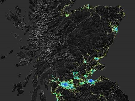
This online session introduced the Network Planning Tool, which predicts the relative demand for cycling on the majority of streets and paths across Scotland.

The tool will provide a national and objective evidence base, which Places for Everyone partners will be encouraged to use, to help identify and prioritise infrastructure proposals in their Active Travel Strategy. Ahead of the completion of the tool, scheduled for the end of 2023, a prototype was released to partners in April.

This session covered:

  • why the tool is being developed
  • how it works
  • how the prototype compares to the complete tool
  • how it is envisaged the tool will be used by Sustrans and partners.

Session recordings

In the first recording below, we hear from:

  • Simon Strain, Head of Programme (Grants) at Places for Everyone;
  • Matt Davis, Principal Mobility Planner at Sustrans Scotland; and
  • Robin Lovelace, Associate Professor of Transport Data Science at the University of Leeds, and one of the developers of the tool.

In this second recording, we hear from Russell Pepper, a Sustrans Senior Project Officer embedded in Dundee City Council. Russell talks about his experiences of using the tool alongside the Council’s Cycling Strategy.

Questions and answers

Q: Can the tool accept data from Local Authorities and other partners to make it more accurate at a local level?

Great question. No, the tool only takes input datasets that are available for all of Scotland currently. We may in future versions allow locally specific input datasets but that is not in the near-term roadmap. You will be able to download datasets to compare with locally specific datasets such as new housing developments, planned interventions, however. Which local input datasets were you thinking of Vikki?

Q: Will the Network Planning Tool be integrated into any of the Regional Transport Models?

We do not control regional transport models so this is not within our gift. However, we are open to conversations about sharing NPT outputs to feed in, or using outputs from other models to feed into the NPT although we will prioritise national and open input datasets.

Q: How can we ensure that rural areas that don’t necessarily have as much demand as cities, can still get funding for these important corridors?

The addition of other trip purposes (e.g. school) will help with that. The Phase 2 option of adding public transport integration and showing the cycling components of longer mutli-modal journeys will help in the longer term.

Q: How effective is the tool in less urban areas? (, Argyll and Bute Council)

This early prototype version of the tool is less effective in rural areas as it’s based on commute data, which accounts for a disproportionately low share of cycling trips in rural areas. This will be addressed as we add more trip purposes in future versions. School and other everyday journey purposes will be included in the release of the tool at the end of 2023. In the future there is the possibility to include leisure/recreational journeys as well as the cycling component of longer multi-modal journeys, which will further increase the effectiveness in rural areas.

Q: How will tool take account of increase of e-bikes? As distance and especially hills become less relevant to e-bike riders.

We will include an E-bike scenario and E-bike specific routing options.

Q: How does the tool deal with identifying origins and destinations in rural areas where most data zones are quite large?         

The tool uses a Jittering method to disaggregate flows in large data zones. Currently we’re using Output Areas for subpoints but we can use other subpoints for origins and destinations. Any suggested datasets for origins and destinations in rural areas? See here for an overview of the Jittering approach used: https://findingspress.org/article/33873-jittering-a-computat…

In future versions we will use smaller zones as the basis of the commuting origin-destination data and we have commissioned this data from NRS. This will be completed for inclusion in the release at the end of 2023.

Q: The test version of the NPT doesn’t appear to show any cycle data in many rural areas and islands. I understand some locations may not show potential for many cyclists but nothing is shown for Cycle Friendliness or Gradient either, can this be shown for all roads/routes irrespective of use forecasts?

As per the ‘effectiveness of the tool in rural areas question’, the current lack of cycle data in many rural areas and islands is expected to be addressed by inclusion of additional trip purposes into the tool.

In terms of not showing cycle friendliness or gradient where there are no forecast trips, there are several practical reasons why this is done. Firstly the cycle friendliness and gradient are generated at the routing stage. So, any road with no cycle demand in our model has no data to visualise. To infill these missing roads, we would have to create additional routes to fill in the gaps. This would require an enormous amount of additional routing, and it would undermine our goal of updating the tool on a monthly basis. Secondly, by only showing data for roads that have some cycle demand we significantly reduce the volume of data that is stored on the server and sent to the user’s device. Including data for every road in Scotland would increase the data requirements by about an order of magnitude. This would significantly reduce the performance of the tool and increase the cost of web hosting.

However, some of the missing roads will be added as we add different journey purposes. Experience from England, Wales, and the Republic of Ireland show that the non-commute purposes produce very different networks. So, it is likely that this will also be true in Scotland.

One thing to note is that when viewing the cycle friendliness or gradient maps the choice of network type matters. For example, a busy road with no cycling demand under the “quietest” type will not show a gradient of cycle friendliness even if the data is available. You can check for this by switching between the different network types. This is an aesthetic choice we made to make the network confident with the number of cyclists view. But we would welcome your feedback.

Q: Will cycle tourism data be a filter options in later versions?

Including recreational cycling as a journey purpose is under consideration for development during 2024 .

Q: Can you export maps and GIS file formats from the online platform?

Not currently, but we plan to add this functionality when we publish v0.2, which will include travel to school potential in a combined network.

Q: Is the ‘number of cyclist’ filter ‘per day’?

Yes, this corresponds to the number of cyclists on a typical day. We will shift to AADT (annualised daily traffic) estimates for the final version.

Q: What data/information is used to determine cycle friendliness i.e. hostile or quiet, how up to date is this?

Please see the section of the manual in the development version of the tool: https://nptscot.github.io/manual/#map-controls

Q: Rural recreational cycling is also an economic growth opportunity. Will this be considered more going forwards?

Yes, there’s potential to include this in phase 2.

Q: How can you ensure that the Go Dutch model is accurate if the data used is 12 years old? Can you provide a link to the methodology for this model, please?

The current prototype does use 2011 census commuting data. This will produce networks which emphasise arterial routes to major employment centres. The current distribution of residential and major employment sites is likely to have many similarities to that in 2011, so we expect the results to be broadly applicable to the current picture. We are also updating the commuting layer prior to the end of 2023 to take account of recent population growth estimates. However, once the 2022 Census journey to work results are released, we plan to update this layer.

In addition, prior to the end of 2023 release we will also include travel to school and other everyday trips which will have different source data and baselines. For example the travel to school data was collected in September 2022, so the baseline for the Go Dutch Travel to School layer will be more recent.

The Go Dutch scenario itself was originally developed for the Propensity to Cycle Tool and the methodology is described in the Propensity to Cycle Tool manual https://npct.github.io/pct-shiny/regions_www/www/static/03a_manual/pct-bike-eng-user-manual-c1.pdf .

This information will also be included in the Network Planning Tool manual prior to release at the end of 2023.

Q: How is the baseline data calculated and how often is the website kept up to date?

The current prototype baseline data is from the 2011 census for journey to work. We plan to update with the 2022 census data when this becomes available. The website is currently kept up to date on a monthly basis.

Q: What is the network based on? I looked up Inverness. It did not show remote paths / routes for example locks are used to cross the canal. This means that a busy active travel route is not showing up on the tool.

The current prototype only includes commuter flows so routes that are heavily used by other trip purposes (such as shopping, recreation, school travel) will not show up. We will be adding more trip purposed before the full launch at the end of the year. Also by default the tool shows the fastest routes, these may be on very busy roads that in reality cyclists avoid. We do this to highlight places that cyclists may wish to cycle, but can’t due to a lack of suitable infrastructure. Finally our routes are calculated by cyclestreets which is in turn based on the OpenStreetMap (OSM). It is possible that an error in the OSM (e.g. a missing path link) is preventing routing in this area. So we suggest checking planning a cycle route on the cyclestreets website, in the immediate area where this issue occurs. This should identify if cyclestreets is picking up the path(s) in question, as part of cycle route planning. If an error is identified it is possible to edit paths in OSM, which may fix this problem.

Q: Are there any plans to link this tool with existing cycle counter data?

Cycle count data will be one of the data sources used to validate the tool’s outputs prior to release at the end of 2023.

Q: Is there more info on how cycle friendliness is calculated, that can be put on the system in the help section?

Good question, yes the friendliness score is from CycleStreets, they have more detail here: https://www.cyclestreets.net/help/journey/howitworks/#quietness  I’ve made a note to add this to the manual in our issue tracker: https://github.com/nptscot/nptscot.github.io/issues/60 Any more feedback on there is welcome!

Q: Are there any plans to develop a layer to map existing cycle use-age / counts to assist in validating the tool? Strava heat maps are only partial data but can be an eye opener on what is actually being used

We are not currently planning to add visualisations of cycle count data into the tool. Cycling Scotland have an open data platform that displays Scotland-wide cycle count data. However, we are planning to use this cycle counter data to validate the tool’s outputs prior to release at the end of 2023. Strava data has a bias towards leisure & recreation journeys so we are not currently planning to use this in validation. However predictions of leisure & recreational journeys are being considered as a function to add to the tool during 2024. If so Strava data will be one data source that is likely to be used to build this function.

Categories
Engage • Inspire • Learn PfE

Active Travel in Europe: Low Traffic Neighbourhoods

Poster image with 'Active Travel in Europe: 8th-29th June'

About the Series

In the second edition of the series Active Travel in Europe, we explored low traffic neighbourhoods, also known as superblocks, across Europe with practitioners from five different cities – Barcelona, Utrecht, Vienna, Berlin, and Edinburgh.

The fantastic selection of keynote speakers brought different perspectives and experiences in this year’s theme. Ragnhild Sørensen, Head of Communication at Changing Cities, discussed how they are creating superblocks (kiezblocks) from a bottom-up view in Berlin. Florian Lorenz and Georg Wieser of Studio LAUT presented their work on the first pilot superblock (supergrätzl) in Vienna, and the ongoing pan-European r+d project TuneOurBlock – which examines how to expand the superblock concept as a policy and strategy tool. Hans Karssenberg, partner at STIPO, gave a presentation about their work in creating a low traffic neighbourhood from scratch – in a new residential district of Utrecht.

Sílvia Casorrán Martos, Deputy Chief Architect at Barcelona City Council, discussed how superblocks (superilles) form a critical component of the city’s Urban Mobility plan. Patrick Kappert, board member of the Collective Superblock Poblenou neighbours organisation, joined us in our closing panel session to shed light on community organising through the development of Barcelona’s first superblock in Poblenou. Bringing the series back to Scotland, Miles Wilkinson, Senior Project Manager at City of Edinburgh Council, shared his experience of delivering Leith Connections, reducing traffic and improving walkability in Leith.

Finally, we closed this second edition of Active Travel in Europe with a panel session to address recurring themes such as community engagement and participation, political challenges, and placemaking.

You can revisit last year’s discussions by checking out the 2022 Active Travel in Europe event page.

Event Recap and Recordings

Recordings from presentations are available below and slides are posted where available. In addition, a resource pack is available that includes a number of articles, videos, and tools that speakers mentioned within their presentations. It is a non-exhaustive list and serves to provide additional reading.

Berlin

‘How Berlin is using a bottom-up approach’ was presented by Ragnhild Soerensen of Berlin-based advocacy organisation, Changing Cities.

Access the presentation slides. Password: LTNsummer2023

Utrecht

‘Developing for human scale: the city at eye level in Merwede, Utrecht’ was presented by Hans Karssenberg, partner at Dutch firm STIPO.

Related event: Placemaking Europe, Strasbourg, 26-29 September

Access the presentation slides. Password: LTNsummer2023

Vienna

‘The Viennese Supergrätzl and the quest to build research across Europe’ was presented by Florian Lorenz of LAUT Studio in Vienna.

Access the presentation slides.

Barcelona

‘Challenges in transforming public space and mobility in Barcelona’ was presented by Sílvia Casorrán Martos, Deputy Chief Architect at Barcelona City Council.

Access the presentation slides. Password: LTNsummer2023

Edinburgh

‘Leith Connections: navigating design and engagement in Edinburgh’ was presented by Miles Wilkinson of City of Edinburgh Council.

Panel Session

Speakers from the series were invited back for a closing panel session to be in conversation with each other and address recurring themes throughout the series. The panel session includes an additional speaker, Patrick Kappert of Collectiu Superilla Poblenou, a community group in Barcelona that was critical in the implementation of Barcelona’s first superblock.

Watch the recording below as we discussed engagement and participation, political challenges, and placemaking.

Categories
Engage • Inspire • Learn PfE

Designing with Children and Young People

Event video: Catch up on the highlights of the day

Welcome to our event! On this page you’ll find all the information about the agenda, speakers, and resources. Simply click on the headings below or scroll through to see the relevant section.

Agenda

See below for the agenda.

🎟️ 9:30 – 10:00 – Check in and Arrival

Collect your badge and enjoy breakfast bites, teas, and coffees.

🎤 10:00 – 11:00 – Welcome and keynote

Room: Proclaim

Why does creating for and with young people matter? Karen McGregor, Director of Sustrans Scotland, opens the day with welcoming remarks. Afterwards, hear from colleagues in Orkney Islands Council discuss the creation of the intergenerational Papdale Park.

Presented by: Garry Burton (Orkney Islands Council), Michael Harvey (Sustrans embedded officer at Orkney Islands Council), and Liz Leech (HarrisonStevens)

11:00 – 11:15 – Coffee Break
💡 11:15 – 12:35 – Spotlight Sessions

In this morning block, you’ll have the opportunity to attend two case studies. The sticker on your badge lets you know which room to go to first. There is a 10 minute comfort break in between sessions.

Connecting Woodside – Garscube Road
Room: Proclaim
🚲Bike Group – 11:15-11:50
👟Walking Group – 12:00-12:35

Connecting Woodside is an ambitious area-based project forming a key component of Glasgow’s proposed city-wide cycle network. Glasgow City Council have recently completed Phase 1 of the project, a 1km bi-directional, segregated cycle route on the A81, Garscube Road. The Council, through a number of community engagement events and focus groups undertaken with disability groups, developed a fully inclusive design that prioritised those walking and cycling.

Presented by: Aidan O’Meara, Assistant Group Manager, Glasgow City Council and Malcolm Hall, Engineering Officer, Glasgow City Council

Engagement Techniques in Kilbarchan Pocket Place
Room: Aspire

👟Walking Group – 11:15-11:50
🚲Bike Group – 12:00-12:35

Activate your senses and let a charming pig on a scooter bring a smile to your day. Join us to hear about how between June 2019 and June 2020, we co-designed and trialled changes to the street outside a school in Renfrewshire. The project aimed to encourage walking and wheeling through the creation of a safer and more pleasant urban environment.

Presented by: Christina Eley, Delivery Coordinator, Education and Young People

🍽️ 12:35 – 13:20 – LUNCH
💡 13:20 – 16:00 – Afternoon Workshops

Apply this morning’s learnings and take a deep dive into the Designing with Children and Young People toolkit. You will stay in the same groups as this morning (check your sticker).

How to apply child-friendly design in School Streets

Room: Proclaim
🚲Bike Group -13:20 – 14:35
👟Walking Group – 14:45 – 16:00

Let’s put the 12 dimensions of child-friendly design into action! Facilitated by the Sustrans design team, this workshop invites participants to think like a designer and consider the needs of a school street from a child’s perspective. Using the dimensions of child-friendly design from the toolkit, you will apply these to a real-life scenario.

Presented by: Paul Ruffles, Principal Urban Designer, Sustrans and Leti Valle, Urban Designer, Sustrans

Codesigning places with Children and Young People: Why, How and When?

Room: Aspire
👟Walking Group: 13:20 – 14:35
🚲Bike Group: 14:45 – 16:00

The goal for this session is for you to gain a sense of what good engagement in place-based projects looks like from the perspective of children and young people. We will work with you to reflect upon:

  • Why engagement with children and young people is important;
  • Why different ages and settings require different approaches;
  • What ‘good’ looks like in your own and others practice, and how to measure success;
  • How to align the Places for Everyone toolkit with the process and outcomes of engagement; and
  • Fears and prejudices towards meaningful engagement of children and young people, and strategies to overcome them.

Presented by: A Place in Childhood; Dr. Jamie Hamilton and Dr. Jenny Wood

🌇 16:00 – Closing and Final Remarks

Reflect on the day’s learnings and share your takeaways from the day. Guests are welcome to stay back for some post-event networking.

Speaker Bios

Read all about today’s speakers in our compiled list of speaker bios:

Resources

Access key resources from today’s event:

Categories
Engage • Inspire • Learn News News & Opinion PfE Places for Everyone

Places for Everyone Application Information Session – Community Groups

Final submissions for Places for Everyone Concept (Stages 0-2) applications are due by the end of August 23rd 2022.

Ahead of this, an information session was delivered to community-led organisations, which had received a successful Expression of Interest outcome. A small cohort of the Places for Everyone team provided an overview of the Application Guidance and supplementary guidance for community-led organisations and outlined the next steps in the process.

Key questions answered

  1. Are letters from stakeholders (for example, support letters) required?
    They aren’t required; however, they will support your application as evidence.
  2. How detailed should the estimated costs be, and do you have advice on what approach to take when calculating these figures?
    We don’t expect accurate figures, so provide your best guess at this stage.

  3. Is there guidance on existing project costs to refer to?
    Sustrans have not created guidance for this because it can vary significantly. It is a good idea to use the resources you have, and you can search online for comparable projects. The important part is evidencing why you have come to that conclusion. Transport Scotland has some guidance on their website on to arrive at estimation costs.
  4. Do you have a list of consultants and contacts that have been involved in similar work?
    We are unable to provide a list of consultants or to provide recommendations taking in to account it is public funding.
  5. Is it possible to arrange an appointment with a Grant Advisor before submitting the full application?
    We can arrange individual appointments for those who would find this beneficial and have received a successful Expression of Interest outcome. To arrange this, please email PlacesForEveryone@sustrans.org.uk with suggestions of dates/times that are convenient for you.
  6. Is it okay to have an overlap in the delivery team e.g., Community Engagement Lead and Communications Lead to be the same person?An overlap in the delivery team is acceptable.
  7. Is an email sufficient evidence of support from local authorities?
    Yes, if it is clear and it has a signature with their name, job title and organisation.

Full slides from the session can be downloaded below:

Categories
Engage • Inspire • Learn News News & Opinion PfE Places for Everyone

Places for Everyone Application Information Session – All Partners

Final submissions for Places for Everyone Concept (Stages 0-2) applications are due by the end of August 23rd 2022.

Ahead of this, Heads of Programme Chiquita Elvin and Simon Strain outline the key changes to the Places for Everyone application process and answer a number of questions from applicants.

Key questions answered

  1. How essential is it for local authorities to submit Expressions of Interest for new projects?
    Expressions of Interest allow applicants to receive a quick response on whether their project proposal aligns with the aim of Places for Everyone, thereby reducing the time expended on a full application for a project proposal that is not eligible.
  2. If a project is being delivered as a trial within a calendar year, what stage should this be submitted to: 0-2, 3-4, 5-7?
    We consider trials from stages 0 to 4, therefore it would be 100% funded. If you’re needing to run trials to decide on a preferred option, then we’re happy to discuss this with you to determine which stage the trial would be most appropriate.
  3. Will Sustrans consider retrospectively funding projects?
    For consistency and transparency, we’ll be looking to only be funding work into the future or yet to happen.
  4. If your Expression of Interest is unsuccessful, can you make amendments to your proposal and still apply through the portal?
    Yes, Places for Everyone can provide feedback on why the project was considered ineligible. Changes can then be made in response to this feedback and a second expression of interest submitted to reassess eligibility.
  5. Is the fund open to local authorities only or can community councils/groups apply if they have a proposal?
    The fund is open to applications from community organisations including community councils, development trusts and more. We would encourage interested parties to read the guidance for community organisations.
  6. If we have undertaken Concept (Stages 0-2) with another agency, should we still submit our expression of interest?
    Yes, the expression of interest assesses the project’s eligibility for funding. Please refer to the deliverables for stages 0-2 to assess if all deliverables have been sufficiently met by the previous agency.
  7. Have you increased your standards (i.e. paths should be a minimum of 3 metres in width)?
    Working to the standards specified in Cycling By Design, the width of paths in our projects should be appropriate for the estimated levels of usage. The benefits of a wider path enable improved comfort, travelling side-by-side, social experiences, and more robust infrastructure. However, we recognise there are barriers to development, such as width constraints, geological constraints, and land ownership. We promote a width of at least 3 metres wherever possible.
  8. Is there support available to go over draft applications ahead of submission?
    This service is not currently available, though we wish to organise this in future – recruitment is ongoing. Currently, we can offer technical support for all applicants, and additional application support for community groups.
  9. Due to heritage constraints, it’s not easy to build cycle infrastructure (e.g. cycle lanes on setted streets). Will this type of project be scored lower or will this be something that is taken into consideration?
    Scoring for this type of project would not be affected. We would encourage consideration of alternate routes that utilise streets that are un-setted, safer or more suitable.

  10. Is there any additional support for community groups with the application?
    We have organised three Applicant Information Sessions for community organisations during week commencing Monday 15th August 2022, which are available to community organisations who have submitted an expression of interest and were successful at this stage.

Full slides from the session can be downloaded below:

Categories
Engage • Inspire • Learn News PfE

Components of a Behaviour Change Plan

A concrete and well-designed Behaviour Change plan can play a crucial role in determining the overall success of an active travel infrastructure project.

This can affect everything from the level of early engagement you are able to develop within a community, to the way a project is received in terms of infrastructure usage once construction is complete.

The resources below outline the key elements of developing your own Behaviour Change Plan and should serve as a guide to take your project forward.

Categories
Engage • Inspire • Learn News PfE

Roadspace Reallocation in Scotland

In the recording below, we hear from Anna Gale from Public Health Scotland, who give an overview of the findings and recommendations from the Health Impact Assessment.

Find out more about the Health Impact Assessment and Rapid Evidence Review here: https://www.publichealthscotland.scot/publications/road-space-reallocation-in-scotland/

Categories
Engage • Inspire • Learn News PfE Places for Everyone

Active Travel in Europe

Introduction

We hear from a fantastic line up of speakers who present and share experiences of the increase of temporary active travel interventions and strategies during the pandemic in Europe, and how these can shape the way for future long-term measures and solutions. By coming together and learning from each other, it may be possible to keep this momentum going – to transform temporary solutions into more permanent implementations and accelerate the development of sustainable active travel infrastructure across Europe.

The event poster for the Active Travel in Europe webinar series

Paris

Clotilde Imbert, Director of Copenhagenize France, presents case studies from Paris, a city that has seen an increase in temporary cycle paths but also a high increase in cycling since the beginning of the pandemic. In addition, the mayor of Paris, Anne Hidalgo, has an ambitious strategy, ‘Plan Vélo’ to transform Paris into a cycle-friendly city.

According to European Cyclists’ Federation, since the pandemic, France has added €300m in funding for the country’s cycling infrastructure. In the opinion column, ‘A unique opportunity to speed up the implementation of bicycle plans‘ on Copenhagenize’s website, Clotilde expands on her view of the possibilities and strategies that she believes should take place as a next step in creating permanent active travel infrastructure in France.

Brussels

Florine Cuignet, Policy Officer of GRACQ, shares how GRACQ represents cyclists and promotes cycling in the french-speaking parts of Belgium. According to European Cyclists’ Federation, Brussels is one of the cities that implemented the most cycle lanes during the pandemic in Europe. In addition, the country added almost €480m in their cycling infrastructure budget in response to the pandemic.

Last year the Belgian federal government, for the first time, published a cycling action plan for the country. The plan consists of 52 action points that will facilitate and promote cycling, which will be implemented by 2024.

EuroVelo

Ed Lancaster, Director of EuroVelo at the independent non-profit association European Cyclists’ Federation, presents case studies from rural areas in Europe. EuroVelo (European cycle route network) is a cooperation between different national and regional partners. The aim is to ensure that there are very high quality European-grade cycle routes and networks across Europe.

In January, EuroVelo presented the news that cycling on the EuroVelo routes have continued rising since the pandemic. In addition, ECF is also partner for the cross-border BIGIMUGI project that ‘aims at developing cycling mobility for all in rural areas situated along EuroVelo 3’.

Berlin

Ragnhild Sørensen shares more about work that the Berlin-based organisation, Changing Cities, do. As many other cities, Berlin has created pop-up cycle lanes during the pandemic, something that has not been appreciated by all political parties. The pop-up cycle lanes were monitored and developed according to feedback. The organisation has also launched the campaign Kiezblocks in Berlin, where more than 50 local initiatives want to limit the permeability of the road network for motorised individual transport (MIT) while prioritising walking and cycling on non-arterial streets. Kiezblock is a strategy for transformational urban adaptation, initiated by locals.

Panel Session

In this panel session, we welcome back all keynote speakers to answer pre-submitted and unanswered questions. The panel session will also include discussion around key themes identified throughout the series, including:

– Shared learning

– Behaviour and culture

– Opportunities and constraints

Categories
Engage • Inspire • Learn News PfE

Behaviour Change Interventions – Information Sheets

Evidence suggests that the most efficient mechanism for boosting active travel is a mix of interventions that complement each other (e.g. infrastructure interventions and behavioural interventions like a route planning training).

In Places for Everyone we therefore ask applicants to design a mix of behavioural interventions alongside their infrastructure projects, and present these in a behaviour change plan.

Intentionally developing and implementing a plan of activities will increase the use of new infrastructure at the outset and ultimately increase the impact it has.

Start by considering your local context (the local people and organisations), engage and listen. Design a plan just as you would design infrastructure; in a context specific way and in response to feedback. This may it take more time but is well worth it and important.

Categories
Engage • Inspire • Learn News PfE

Community Engagement & Behaviour Change in Places for Everyone

Introduction

This page offers materials and bite-sized, interactive tutorials on understanding and delivering community engagement and behaviour change in Places for Everyone projects.

This includes a practical guide to behaviour change strategies and interventions, as well as a community engagement guide, and the types of community sector organisations. Please note that you can find the references and relevant resources at the bottom of this page.

This page is a work in progress an will be updated with new materials frequently. Your feedback will help shape future sessions and materials.

Developing a Behaviour Change Plan

In this session, we cover:

  • Why behaviour change plans are important;
  • What behaviour change plans should include;
  • Community engagement vs behaviour change;
  • Involving seldom-heard groups;
  • Selecting interventions; and
  • Key points to remember.

Putting Theory into Practice

The session above, “Developing a Behaviour Change Plan”, mentions that one of the most effective mechanisms for boosting active travel is a mix of measures that complement each other. Infrastructure is just one measure we can use. In this session, we take a practical look at how to put together an effective programme that will result in a greater diversity of people using the infrastructure.

Introduction to Behaviour Change

In this session, we cover:

  • What is behaviour change?
  • ISM and Shifting Normal models
  • COM-B and the Behaviour Change Wheel
  • Tying it all together using a real life example
  • Making things happen

Introduction to Community Sector Organisations

In this session we’re going to look at community organisations in a bit more depth. We cover:

  • Explanation of the terms Community Sector, Third sector and Voluntary sector
  • Types of community organisation
  • Legal structures
  • Social enterprises and BIDs

Community Engagement and Co-production

Our Community Engagement Guide 2022 provides an overview of best practice in community engagement and allows you to easily identify which deliverables and activities are appropriate at each stage in the process. This guide covers:

  • An overview of community engagement standards that underpin effective and purposeful engagement
  • Community Engagement activity by project stage

Stakeholder Register and Mapping Template

This template offers:

  • A stakeholder register for easy recording and categorising of stakeholders
  • A stakeholder map for visual representation of the stakeholders involved in your Places for Everyone project
  • A list of generic stakeholder groups that you may consider for your stakeholder register/ map

References and relevant resources